Enterprise


Beyond Visual Line of Sight (BVLOS) Drone Regulations: Why Full Autonomy Matters Under FAA’s NPRM
By: Dawn Zoldi* As the United States approaches unlocking routine nationwide Beyond Visual Line of Sight (BVLOS) drone operations, industry must fully embrace higher levels of autonomy to realize the...Read More

The Fine Print of Part 108: BVLOS Gotchas That Could Trip Up Energy Operations
By: Nate Ernst, AG Energy Ambassador The FAA’s new Part 108 Notice of Proposed Rulemaking (NPRM) lays out a sweeping framework for Beyond Visual Line of Sight (BVLOS) operations—regulations that...Read More

Electric Utilities & Drones: Innovation vs. Security
By Michelle Duquette (CEO, 3 MAD Air) & David Lewin (Host, This Week in Drones) The conversation about drones and remote identification (Remote ID) continues to race ahead, but too...Read More

Fulcrum and the Next Level of Fieldwork: Intelligent Operations for the Energy and Infrastructure Sectors
Across electric, water, and gas utilities—along with pivotal infrastructure contractors—field teams face a tangled web of manual paperwork, disconnected digital tools, and the ever-present mandate for safety, uptime, and regulatory...Read More

DFW Airport Goes Digital With Geospatial Data, AI/ML and Event-Driven Architecture
With a land area rivaling Manhattan and a passenger volume among the world’s highest, Dallas Fort Worth International Airport (DFW) faces the immense challenge of modernizing infrastructure, enhancing passenger experience...Read More

FlyFreely: The Software Powering Drone Program Success
Drone operations are no longer a novelty—they’re a necessity for organizations that want to stay competitive, compliant and safe. Drawing on insights from FlyFreely co-founder Dr David Cole’s recent appearance...Read More
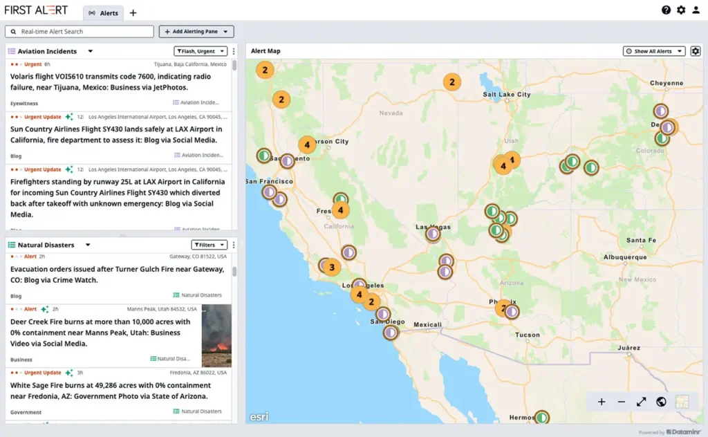
Esri’s ArcGIS Basemaps Power Dataminr First Alert for Enhanced Real-Time Event Detection and Awareness
Esri, the global leader in location intelligence, has partnered with Dataminr, the leading real-time AI platform, to enhance real-time emergency response for public organizations. Esri’s ArcGIS Basemaps will be integrated into...Read More

The Compliance-Autonomy Cycle Driving Big, Big Energy Results in the Sector
The energy sector demands regulatory compliance. The promise of technological autonomy has reshaped how oil, gas and utility companies operate. A virtuous circle has formed around the requirements and the...Read More

Drones, Data and Ingenuity in the Energy Sector: Advanced Corrosion Detection Beneath Insulation
In the oil and gas industry, corrosion under insulation (CUI) is a silent threat—one that can cost companies millions, disrupt operations, and pose significant safety risks. Traditional CUI inspection methods...Read More

There’s No Silver Counter-Drone Bullet: Build a Stronger Cyber-Centric Shield, Layer by Layer
Today, drones are just as likely to deliver packages as they are to disrupt critical infrastructure or military operations. As the need for robust, adaptable counter-drone solutions becomes increasingly apparent,...Read More