Over cities across America, drones have taken flight and have become an integral part of our urban landscape. From package deliveries to emergency response, drones have improved the way local companies do business and governments serve their communities.
With this technology comes a complex web of challenges that many municipalities, cities and states remain ill-equipped to handle, from airspace management, public safety, privacy concerns to regulatory compliance.
As communities grapple with these issues, a pressing need for a comprehensive drone operations management (DOM) system has emerged. Enter: Airspace Link, the bleeding-edge company that’s helping state and local governments navigate the drone revolution with the tools to manage what happens in their airspace.
The Challenge of Airspace Management
The drone industry continues to experience significant growth – and government agencies stand at the forefront of adoption. In Minnesota alone, law enforcement reported a staggering 268 percent increase in drone deployments between 2020 and 2023.
It’s not just governments using drones. As of March 1, 2025, the FAA logged over a million recreational drone users. The number of commercial drones registered and licensed sits at almost 500,000.
Besides the influx of drones in communities’ skies, recent incidents, such as the drone hysteria in New Jersey, have underscored the limitations of current legal frameworks and technological capabilities in addressing unauthorized drone activity.
As municipalities and cities grapple with these concerns, more often than not their approach to DOM – assuming they have an approach at all – remains fragmented. This can lead to:
- Resource inefficiency: duplicated equipment, underutilized drone assets, inconsistent training and limited resource sharing between departments.
- Safety and compliance gaps: due to the struggle to maintain consistent safety protocols, ensure proper operator certifications, track regulatory compliance and coordinate responses to drone-related incidents.
- Operational blind spots: where there’s no central visibility into who is flying, limited ability to coordinate operations, no real-time awareness of other aircraft and difficulty distinguishing authorized from unauthorized operations.
In this environment, Airspace Link has emerged as the go-to solution for comprehensive DOM.

The Power of Data-Driven DOM
Founded with a mission to safely integrate drones into the national airspace system (NAS) and local communities, Airspace Link has developed AirHub® Portal, a sophisticated platform that serves as the cornerstone for responsible drone use. This Federal Aviation Administration (FAA)-approved system combines cutting-edge technology with a deep understanding of aviation regulations to provide a one-stop-shop for drone operators and government officials alike.
AirHub® Portal: The Heart of DOM
At the core of AirHub® Portal, the heart of DOM, lies its powerful data-driven approach. The platform aggregates information from over 50 sources, including real-time FAA data, to create a comprehensive picture of the airspace. This wealth of information allows users to assess risks, plan routes and make informed decisions with unprecedented accuracy.
The platform caters to a wide range of users, from individual hobbyists to large government agencies. For local governments, AirHub Portal provides the ability to manage drone activity in one’s jurisdiction with a level of control and insight previously unimaginable. For professional operators and government entities, it offers advanced tools for risk assessment, operational planning and data analysis. For recreational flyers, AirHub® Portal provides essential safety information and airspace awareness through its integration with the FAA’s B4UFLY program.
Streamlined Drone Authorizations…and So Much More
AirHub® Portal initially became widely known among drone pilots for its integration of the Low Altitude Authorization and Notification Capability (LAANC) system. This FAA initiative streamlines the process for drone operators to obtain airspace authorizations for safe and legal flights in controlled airspace. Recent updates to AirHub® Portal have introduced features like variable-height LAANC authorizations. This allows for more complex flight plans that adapt to changing airspace restrictions.
But AirHub® Portal goes well beyond operational authorizations. It serves as a comprehensive DOM tool. It offers features such as crew and asset management, drone registration, usage tracking and support for beyond visual line of sight (BVLOS) operations. This holistic approach covers every aspect of drone management, from pre-flight planning to post-mission analysis.
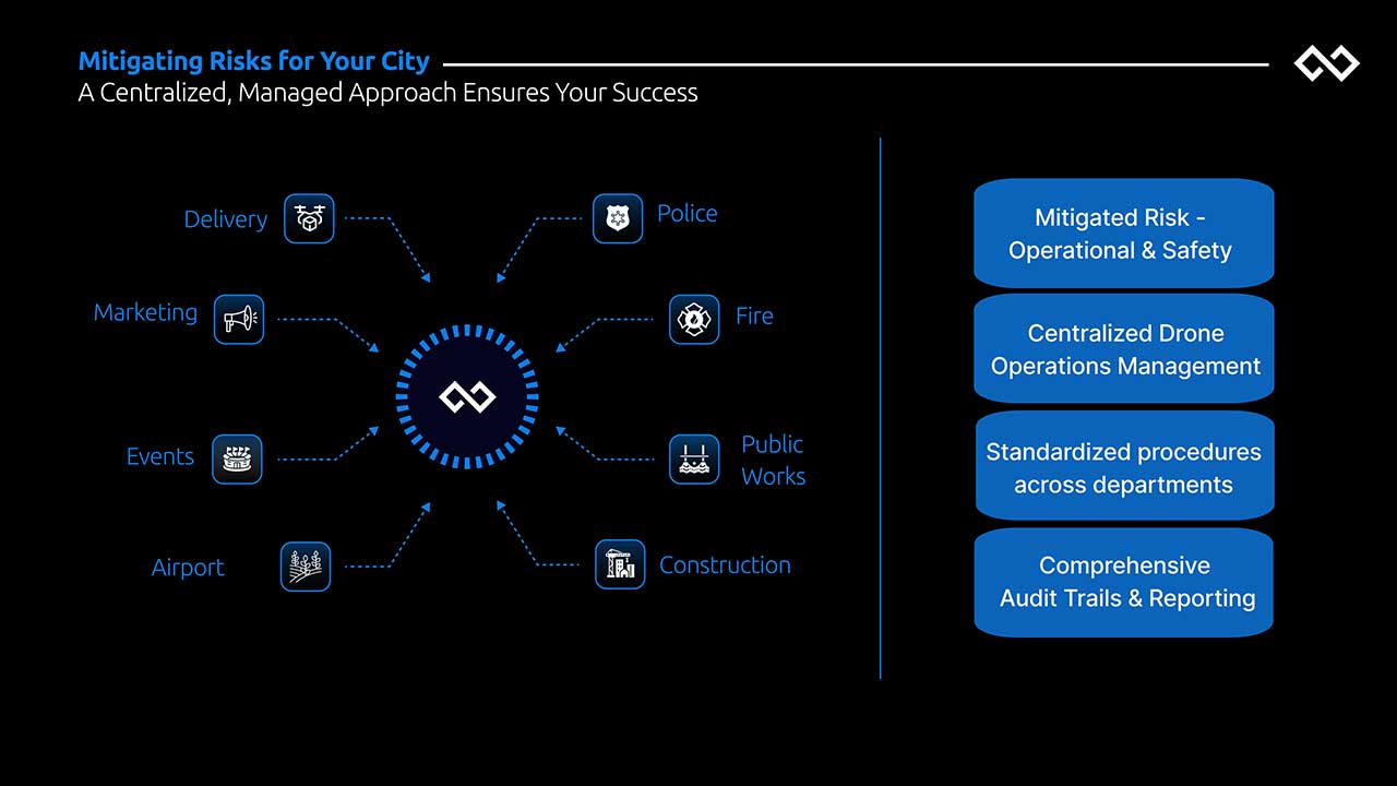
Specifically, for state, local, tribal and territorial governments (SLTT), AirHub® Portal provides a centralized, managed approach to an area’s drone activity through these three essential components:
- The Operations Center: Serves as the drone operations command hub. It provides real-time situational awareness of all aerial activities within your jurisdiction. It maintains a complete data repository of operations which enables comprehensive program oversight and analysis.
- Advanced Airspace Monitoring Infrastructure: Deploys strategically placed Remote Identification (Remote ID) sensors throughout your area of operations (AOR) to provide real-time airspace monitoring. The company also offers expert analysis for optimal sensor placement, procurement and installation support, ongoing maintenance and seamless data integration with existing systems.
- Unified Flight Management Platform: A central hub for all drone operations, providing a single system for airspace checks and safety protocols, centralized management of city drone operations, standardized procedures across departments and comprehensive audit trails and reporting.
Unparalleled Technical Integrations…And More, More, More
AirHub® Portal stands out for its robust technical integration capabilities. It offers several key features that enhance its functionality and adaptability within a SLTT government’s existing infrastructure:
- Full API Access: Provides open API access with machine-readable formats; facilitates seamless integration with other systems and enables custom application development.
- Seamless ESRI Environment Integration: Enables seamless integration with ESRI environments; allows users to leverage existing GIS data and mapping capabilities within AirHub® Portal.
- Comprehensive Database Schema Documentation: Offers comprehensive database schema documentation; makes it easier for developers to understand and work with the platform’s data structure.
- Dynamic Data Exchange Support: Provides dynamic data exchange support; facilitates real-time data sharing and synchronization with other systems.
- Emergency Response Integration: Integration provides capabilities to rapidly respond to emergencies through Automated Emergency Operation Request generation, expedited FAA approval through the Special Government Interest (SGI) process, real-time incident response coordination, emergency airspace management and immediate stakeholder notification.
- Comprehensive Risk Analysis Tools: Includes tools such as ground and airspace assessment, detailed takeoff/landing zone analysis, emergency landing site identification, drone park location optimization, approach and departure corridor planning and automated risk assessment reporting.
- Training and Certification Management: Provides comprehensive training support, FAA Part 107 certification tracking, custom city-specific training modules, ongoing pilot qualification monitoring, and department-specific protocol training.
Add to all of these features, 14 additional key capabilities of AirHub® Portal:
- Airspace Awareness: Real-time visibility into airspace conditions, restrictions, and other aerial activities provides operators with crucial situational awareness for safe flight planning and execution.
- Flight Authorization: Streamlined processes for obtaining necessary approvals from relevant authorities, ensuring all operations comply with local and federal regulations.
- Operation Planning: Comprehensive tools for mission planning, including route development, resource allocation, and operational requirements assessment to ensure successful mission execution.
- Crew & Asset Management: Centralized management of pilot certifications, drone registrations, and equipment maintenance schedules to maintain operational readiness and compliance.
- Hazard & Risk Management: Sophisticated risk assessment tools and hazard identification systems to ensure safe operations in complex urban environments.
- Alerts & Notifications: Real-time communication system for operational updates, safety alerts, and critical notifications to relevant stakeholders.
- In-Flight Management: Active flight monitoring and control capabilities to ensure safe and efficient execution of planned operations.
- City Takeoff and Landing Zoning: Planning/Land Use Strategic planning tools for managing takeoff and landing zones, including analysis of land use requirements and restrictions.
- Conflict Management: Advanced systems for detecting and resolving potential conflicts between multiple drone operations in shared airspace.
- Organization & User Management: Streamlined administration of user roles, permissions, and organizational hierarchies ensures secure and efficient management of all system users and their associated access levels.
- Constraints & Advisories: Dynamic monitoring and communication of airspace restrictions, weather conditions, and other operational advisories that might affect flight operations.
- UAS Traffic Management: Comprehensive traffic management system for coordinating multiple drone operations within the urban airspace environment.
- Detect and Avoid Manned Aircraft: Integration of detect-and-avoid capabilities to ensure safe separation between drone operations and traditional aviation activities.
- Integrated Workflow/Lifecycle: Seamless management of the complete operational lifecycle from initial request through mission completion and post-flight analysis.
Airspace Link’s expertise also extends beyond software development. The company actively collaborates with government agencies to shape drone policies and integration strategies.
This all sounds like the stuff of science-fiction, but it’s real – and the results for Airspace Link’s nationwide government partners have been palpable. In Detroit, Michigan, for example, the company is playing a crucial role in developing the Advanced Aerial Innovation Region (AAIR), a pioneering ecosystem for drone and advanced air mobility operations. (Read more about that in previous AG coverage.)

AirHub® Portal in Action: Common Government Use Cases
The applications for Airspace Link’s technology in local government are vast and varied. Airspace Link’s AirHub® Portal has demonstrated its versatility across various municipal operations.
Emergency Response
When critical incidents occur, AirHub® Portal enables rapid and effective drone deployment. The system identifies qualified emergency response pilots and assets, assesses airspace restrictions, generates optimal flight plans and expedites approvals. During operations, it ensures safe separation from other aircraft, including medical helicopters, while keeping all stakeholders informed.
Infrastructure Inspection Program
For routine infrastructure inspections, AirHub® Portal creates a seamless workflow. It automates scheduling, matches qualified pilots with inspection requirements, assesses potential hazards at each location and ensures inspection flights don’t conflict with other operations. The system also identifies optimal launch points near inspection sites, considering factors like power lines, buildings and public spaces.
Large Event Management
During major city events, AirHub® Portal excels in managing complex airspace scenarios. It coordinates multiple departments’ drone operations, creates secure drone operating zones, maintains safe separation between authorized operations and identifies potential unauthorized drones. The system ensures all authorized operations maintain safe distances and immediately communicates any airspace changes or security concerns to relevant stakeholders.
Routine Commercial Operations
For regular commercial drone operations within the city, AirHub® Portal provides comprehensive oversight and coordination. It streamlines the approval process for routine commercial flights, updates operators about temporary restrictions or changing conditions and continuously evaluates operations against changing urban conditions. The system ensures commercial operations integrate smoothly with other city drone activities and helps operators identify and utilize approved launch and recovery sites throughout the city.
Public Works and Maintenance
City maintenance teams can employ drones through AirHub® Portal to inspect infrastructure like bridges, towers and utilities. This dramatically reduces the time and risk involved in routine assessments while capturing detailed imagery for maintenance planning.
Urban Planning and Development
AirHub® Portal supports urban planning initiatives by enabling drones to capture aerial imagery of city landmarks, parks and development projects. This capability allows cities to showcase urban attractions, monitor urban development and promote community growth.
In short, Airspace Link’s AirHub® Portal provides smart cities with a comprehensive solution for managing a wide range of drone operations in urban environments that enhances safety, efficiency and compliance across multiple municipal departments and functions.
Empowering Smart Cities To Harness the Power of The Skies
As we look to the future, the role of drones in our communities seems set to expand even further. With the advent of drone delivery services and the potential for urban air mobility, the need for robust, data-driven management systems will only grow. Airspace Link’s AirHub® Portal will be essential in helping state and local governments stay ahead of the curve. By providing comprehensive, user-friendly DOMS, Airspace Link is not just facilitating the use of cutting-edge technology – it’s helping to shape the very future of our urban airspace.
By: Dawn Zoldi