By: Dawn Zoldi
On a busy GeoWeek 2026 show floor dominated by airborne and terrestrial systems, CHC Navigation (CHCNAV) stood out as one of the few companies with working maritime unmanned surface vehicles (USVs) on display. Their Apache series—Apache 3 Pro, Apache 4 Pro and the Apache 6—show how far compact USVs have come as practical tools for surveyors, river authorities and marine contractors who need precise data without putting crews at risk.
A Technology-Driven Take on the Water
CHCNAV describes itself as a technology‑driven company focused on “precise mapping, navigation and positioning solutions” that help customers work more efficiently. That ethos appears visibly in the way its USVs pair robust hulls and propulsion with integrated GNSS, inertial navigation and purpose‑built echo sounders for hydrographic work.
Autonomy Global interviewed Technical Support Engineer Tristen Denton at GeoWeek. Denton comes from a geography and surveying background and framed the boats as tools to turn difficult water into routine data. “Seeing is believing,” he said. Watching a USV run a line while streaming usable bathymetry is the fastest way for a surveyor or water agency to understand its value.
Apache 3 Pro: Shallow-Water Workhorse
The entry level of CHCNAV’s lineup, the Apache 3 Pro, presents as a compact single‑beam USV designed for shallow water bathymetric surveys in lakes, rivers, reservoirs and nearshore zones. The boat couples CHCNAV’s GNSS RTK and inertial navigation sensor with an integrated D270 single‑beam echo sounder to deliver accurate depth measurements, even under bridges or in areas with intermittent satellite coverage.
Engineered as a lightweight but rugged platform, the Apache 3 Pro features a carbon‑fiber hull with high impact resistance and a semi‑recessed motor that reduces drag and boosts endurance. Onboard millimeter‑wave radar provides automatic obstacle detection across a wide field of view. This allows the USV to autonomously re‑route around hazards and protect both the platform and the survey payload.
For surveyors, this translates directly into billable work. For public safety agencies, it could mean the difference between life and death. Use cases Denton highlighted include basic bathymetric mapping, volume calculations for pits and ponds and search and rescue operations where a small, easily deployed vessel can access tight or hazardous areas. Combined 4G and 2.4 GHz links with cloud monitoring let operators track and control the vessel in real time without being right at the shoreline.
Apache 4 Pro: Hydrology and Hybrid Missions

Moving up a class, the Apache 4 Pro is a multi‑purpose platform designed to bridge classic hydrographic surveying and riverine hydrology. The USV supports a wide range of Acoustic Doppler Current Profilers (ADCPs) such as CHCNAV’s RiverStar series, as well as third‑party systems like the M9, RiverPro and RioGrande, along with CHCNAV’s HQ‑400 multibeam echo sounder, side‑scan sonar and water‑quality probes.
Compared to the earlier Apache 4, the “Pro” brings a reinforced hull, titanium‑alloy propellers and broader use of carbon fiber for extra rigidity and durability in rougher water and debris‑laden channels. A 50‑kilogram payload capacity and central access shaft give integrators space and flexibility for complex sensor stacks.
From a workflow standpoint, the EasySail Android app is the control center where operators can plan routes, monitor real‑time data and video and adjust survey parameters over 4G and 2.4 GHz links without a dedicated field computer. CHCNAV combines an integrated GNSS + IMU system with adaptive navigation algorithms and anti‑interference transducers to keep data quality high, even in turbulent flows and cluttered acoustic environments.
Denton pointed to use cases like flow measurement in rivers, verifying long‑term discharge data at dams and regular scans of eroding beaches or riverbanks. River authorities and other state water agencies, he said, are already leaning on this kind of platform to backstop decades of hydrological records with dense, repeatable measurements.
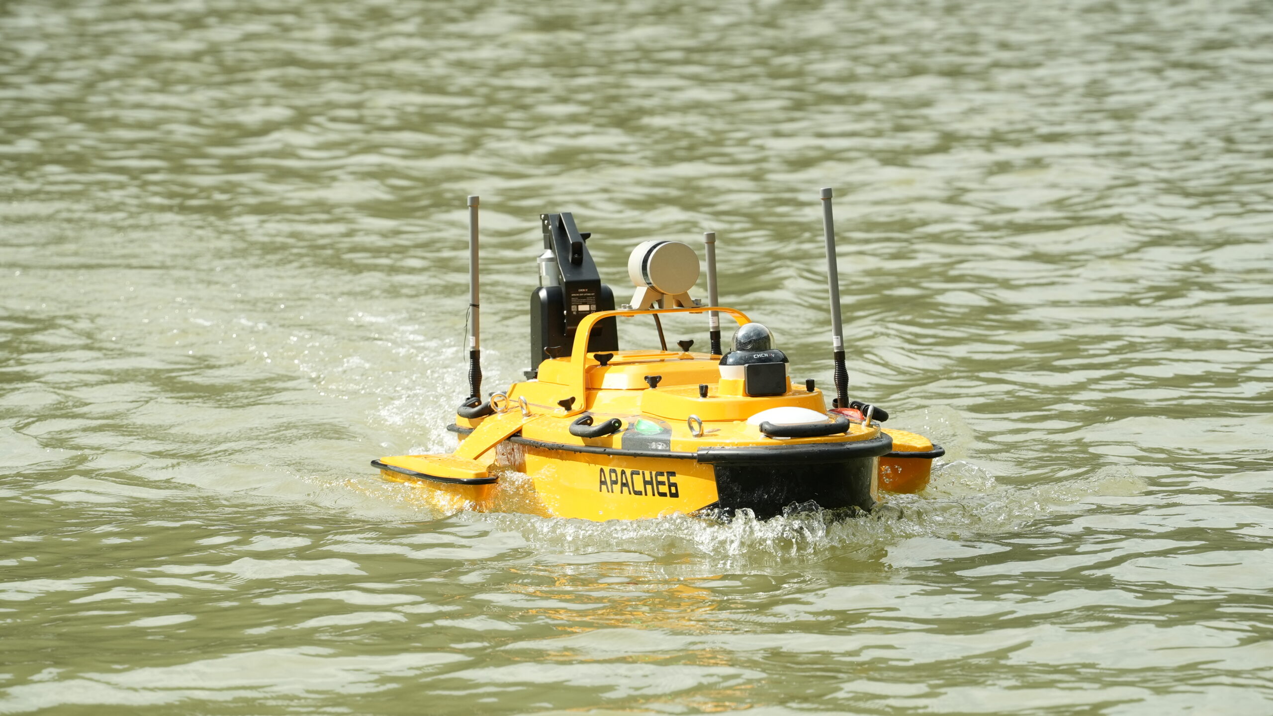
Apache 6: Big Water, Big Data
At the top of the lineup sits the Apache 6, the “beast” of CHCNAV’s stand at GeoWeek. The latest 2026 edition is an integrated USV built around NORBIT multibeam echo sounders, optimized for the iWBMS and WINGHEAD series, to deliver high‑resolution bathymetry and 3D mapping in coastal waters, harbors and offshore sites.
The Apache 6 also supports an optional NORBIT iLiDAR to capture terrestrial 3D data at the same time as underwater measurements. This allows a single pass to map submerged topography along with overhead structures such as bridges, quays, power lines and riverbank assets. CHCNAV layers its own lidar on top in some configurations to create a true above‑and‑below water dataset suitable for complex infrastructure and construction projects.markets.
This system is clearly aimed at heavy‑duty work, such as dredging operations in turbid water, offshore construction support, harbor and channel surveys and mining‑related tasks around tailings ponds or near‑shore facilities. Outriggers and straight‑line control help the vessel hold course in rougher seas, while multi‑link communications and an Android‑based controller provide long‑range status monitoring and data streaming.
Safety, Stakeholders and Humanitarian Potential

Besides the bright orange hulls, the entire Apache lineup shared the more important commonality of keeping people out of risky water while maintaining or improving data quality. Denton cited tailings ponds, turbid dredging sites and similar industrial environments where sending a manned crew is both expensive and hazardous. A USV can run lines, collect sounding data and support decision making without exposing surveyors to those conditions.
On the customer side, he pointed to a spectrum of use cases. Traditional land survey firms with water on their projects now have a path to bring that work in‑house instead of subcontracting, while river authorities and dam operators can use USVs for routine checks of flow rates and discharge. In the open ocean and coastal zones, mining and dredging companies can document sediment movement, verify dredge depths and monitor changing seabeds over time.
While CHCNAV does not position these systems as defense products, Denton acknowledged potential humanitarian applications, such as supporting agencies that map and clear sea mines. The same high‑resolution multibeam and positioning capabilities that make Apache 6 a strong fit for offshore construction could help de‑risk navigation lanes in post‑conflict environments when driven by civil or international organizations.
Why USVs Were a Standout at GeoWeek
Seeing three Apache boats side by side at GeoWeek underscored a broader shift in geospatial workflows. Airborne lidar and photogrammetry often grabs much of the attention in show halls. But now, water, especially shallow and hard‑to‑reach water, is seeing a rising tide of similar treatment. Compact USVs are emerging as everyday tools, rather than exotic systems.
For CHCNAV, maritime USVs are a logical extension of a portfolio that already includes GNSS receivers, drones and mobile mapping systems. For the surveyors, water agencies and marine contractors walking the GeoWeek floor, they represented a pragmatic way to capture hydrographic and hydrological data with the same repeatability, precision and safety they now expect on land. In the end, as Denton said, these boats stop being novelties the moment they start earning their keep on real‑world jobs.
CHCNAV Also Wants You To Know…

Deepened Accuracy in Shallow Waters
“We are committed not only to making USVs smaller and more portable but also to pushing the limits of survey accuracy in shallow and complex waters. In inland water environments, often challenged by turbidity or dense aquatic vegetation, our proprietary algorithms are specially optimized to maintain data quality. This means we truly “make the vessel compact while deepening the precision.”
From Single Vessels to a “Smart Hydrometry” Total Solution
“CHCNAV has a long-standing heritage in hydrometric cableways and gauging systems. Our USVs are not standalone products; they are designed to integrate seamlessly with fixed hydrological stations and online monitoring equipment, forming a “Smart Hydrometry” network. By combining mobile and stationary platforms, we help customers obtain more continuous and comprehensive hydrological data—offering a holistic solution rather than just selling a boat.”
Full-Link Localized Solution for Agile Service
“We provide a complete domestically developed solution covering the hull, high-precision positioning systems (POS), and multibeam echo sounders. With full control over the core technology chain, we can offer extremely responsive after-sales support and flexible customization, ensuring data security while significantly accelerating project delivery.”