By: Dawn Zoldi
As drone mapping matures, the demand for ultra-precise geospatial data grows across infrastructure, construction and transportation sectors. At the Tennessee Drone and AAM Summit, Larry Donelson of InTerra and Seth Ford with Drone615 explored how to transcend the limitations of traditional CORS (Continuously Operating Reference Station) networks. They shared insider lessons and field-tested strategies to achieve sub-centimeter accuracy anywhere, anytime, using advanced workflows and technology partnerships.
What is CORS? The Bedrock of High-Precision Mapping

CORS has traditionally paved the way for centimeter-grade accuracy in aerial mapping projects. CORS networks consist of permanent, high-precision GNSS reference stations that constantly provide real-time and post-processed correction data for positioning applications. Surveyors, engineers and drone pilots leverage these continuous streams to correct GPS errors caused by satellite drift, atmospheric disturbances and other geospatial quirks.
In the United States, CORS is essentially a federal asset. Just as the Department of Defense (DoD) operates and controls the GPS satellite constellation that underpins every GNSS-enabled device, the nationwide CORS infrastructure is coordinated through the National Geodetic Survey (NGS) within NOAA, which aggregates and distributes data from roughly 2,000 active stations as part of the National Spatial Reference System. While many individual CORS sites are owned by state DOTs, universities and private partners, the federal role in managing, quality-controlling and publishing that correction data means access can be disrupted by policy decisions, funding issues, or shutdowns.
Donelson explained, “The advent of self-driving cars and precision mapping heightened the need for reliable ground control. CORS was a game-changer, but even it can be vulnerable, especially when government shutdowns disrupt access to stations.”
How InTerra Takes CORS to the Next Level
InTerra builds on the strengths of national CORS infrastructure by automating how drone teams access, apply and extend high-precision corrections in the field with its SmarTarget™ products.
For non-surveyors, the easiest way to understand InTerra’s approach is to think of three layers working together: the GPS signal in the sky, a “truth checker” on the ground and simple targets the drone can see. Traditional workflows rely heavily on real-time correction feeds called Real-Time Kinematic (RTK). RTK is a GPS technique where a fixed base station with a known position sends live correction data to a moving receiver like a drone, so the drone’s position can be calculated down to the centimeter instead of just a few meters. Remote reference networks like CORS, then act as that “truth checker” by constantly comparing satellite signals against a known fixed location to clean up errors. Post-Processed Kinematic (PPK) goes a step further by recording everything during the flight and then correcting it after the fact using the most accurate reference data available, which is especially useful when internet or network connections are unreliable.

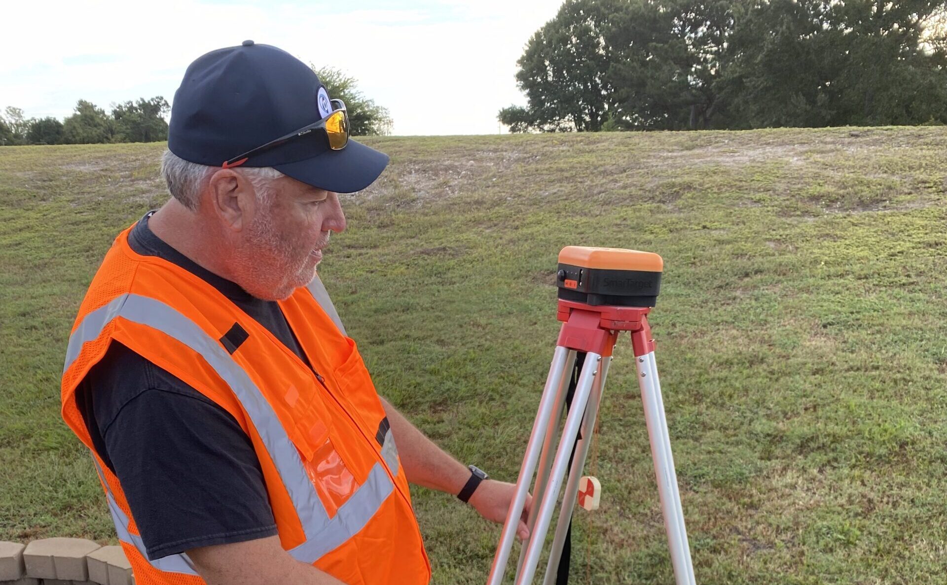
InTerra’s SmarTarget system quietly bundles all of this complexity into hardware and software that feels almost “plug and play” for the operator. Each SmarTarget is a GPS-enabled ground control point (GCP), a marked plate on the ground with its exact position calculated to within centimeters, that the drone can easily see in its photos. Instead of a technician standing over every point with a survey pole, SmarTargets sit flush on the surface, automatically logging high-quality satellite data during the flight and then letting InTerra’s software match that data with CORS or a local base station (InTerra’s own Datum unit) afterward. The result is a highly accurate map that lines up with the real world, delivered with far less field time, fewer chances for human error and no need for the end user to understand the alphabet soup of RTK, PPK or CORS behind the scenes.
Instead of forcing surveyors to manually download and manage CORS files, InTerra’s software stack reaches out to nearby NGS CORS stations, pulls only the time-synced data needed and runs PPK corrections against Datum – local base station which then correct the SmarTarget to produce clean, repeatable positions in minutes. That automation effectively “wraps” federal CORS services in a resilient, field-ready workflow that holds up when public networks are slow, overloaded or temporarily offline.
And InTerra’s SmarTarget is easy to use. It is physically compact. Each unit is roughly a 5 x 5 inch square and about 2.4 inches tall, and weighs just over a pound. That makes it far smaller than a baseball third base bag, and closer in footprint to a small hardcover book. It can sit low and unobtrusive on the ground while still being easy for the drone’s camera (and the field crew) to spot.
Drone615 taps this ecosystem to deliver faster, more reliable and defensible mapping for mission-critical infrastructure. By standardizing on SmarTarget and Datum for ground control and base station duties, Drone615’s teams can generate their own correction factors, maintain sub-centimeter accuracy when federal CORS access is disrupted and dramatically cut both field visits and office processing time.
Ford emphasized this resilience from the operator’s perspective. When government networks go down, traditional survey crews stall. But InTerra’s base station technology lets them “keep working uninterrupted” by simply setting the unit on the ground, connecting and getting to work. This turns lost days into completed deliverables.
Workflow Upgrades: Actionable Lessons Learned
Throughout the session, Donelson and Ford kept returning to a common theme: high-accuracy mapping only matters if the workflow is simple enough to trust every day in the field. Donelson opened that part of the conversation by walking the audience through a live project where SmarTargets were scattered across a site, quietly logging data while the drone flew overhead. There were no radios to configure, no complicated base station setup, just small, GPS-enabled targets sitting on the ground doing their job. “You power on the first one, let it see the satellites, and then go fly,” he explained. “When you’re done, you shut it off and the correction math happens later.”
Ford picked up the thread from the operator’s perspective, contrasting years of manual ground control with what he now does in the field. As a former Marine helicopter and UAS pilot, he drew a straight line between the life-and-death precision of Hellfire engagements and the business-critical precision of construction and infrastructure mapping. In both cases, he argued, accuracy and repeatability are non‑negotiable. Donelson added, “In one test, our smart targets produced more accurate results than traditional survey teams, even where manhole covers and tricky elevation data confounded old methods.”
What changed for Ford with InTerra was how little friction it took to get there. Instead of hovering over every point with a survey pole and worrying about tiny alignment and height errors, he now drops SmarTargets flat on the surface. Because the receiver plate is fixed relative to the ground, the guesswork disappears. “There is no measuring in that aspect,” he told the audience. “So error removed…With sub-centimeter mapping, homebuilders know exactly what they’re getting. There’s confidence in every inch,” Ford asserted.

The two also dug into the balance between real-time and post-processed corrections, a nuance that matters when CORS access is unreliable. Ford described jobs where he had relied on RTK feeds and traditional survey points, only to discover mismatches between what the crew shot in the field and what actually appeared in the map. In one sewer manhole example, the elevation tied to a legacy RTK shot simply did not match reality, while the SmarTarget‑driven PPK solution aligned cleanly with visible features. For the room full of practitioners, the lesson was straightforward: use real-time corrections when they help, but make sure your workflow can fall back on robust post-processed data if the network blinks or the reference is wrong.
Time and cost savings were not theoretical. Ford quantified them. On typical sites, he estimated saving 15–30 minutes in the field simply by not walking every point with a rover and by letting the targets collect data while he flies. “Traditional surveys took hours, even days,” Ford explained. “With InTerra’s workflow, we’re in and out in minutes.”
The office side is even more dramatic. “Office processing is equally fast: plug in the smart targets, download, assign CORS data, all done in under a minute,” Ford noted. After a job, he plugs the SmarTargets into a USB hub, downloads the data, selects the appropriate CORS station (or InTerra’s local Datum base when CORS is offline) and lets the software process everything. “It takes under a minute,” he said, in contrast with the slower, more manual workflows. Those incremental gains add up in terms of fewer truck rolls, fewer reshoots and faster delivery to clients who now expect survey-grade accuracy from drone data.
The most vivid illustration of ROI involved a recent government shutdown anecdote. Ford and Donelson were on a job near a frequently used CORS station when the federal site suddenly went dark. Overnight, the “free” network that underpinned much of the industry’s PPK work was inaccessible. Rather than scrub the mission, they simply leaned on InTerra’s Datum base station, which had been quietly collecting its own reference data all day. Back in the office, that local dataset stepped in for the missing CORS feed, and the project stayed on schedule. For agencies like TNDOT, that kind of continuity spells the difference between meeting, or missing, critical construction windows.
Insights from the Field: Tips to Maximize Mapping Performance
Ford and Donelson’s experiences lend themselves to some practical tactics to achieve ultra-precise mapping across changing job sites. Here’s the list of some heard-earned lessons learned from the field:
- Always Prepare for Network Interruptions: Ford advises carrying local base stations and GNSS-enabled targets in every kit. If CORS stations go offline, switch to local corrections to keep project schedules intact.
- Integrate Smart Targets and Local Base Stations: They offer robust alternatives to vulnerable CORS networks and guarantee accuracy under all conditions.
- Strategic GCP Placement: Distribute GCPs across the entire mapping area, including corners and critical features, to balance horizontal and vertical accuracy. Donelson shared, “No guesswork: correct placement means your data aligns perfectly with the physical site—developers and engineers expect nothing less.”
- Refine Workflows for Speed and Repeatability: Plan GCP locations, streamline data downloads, and use products that eliminate common sources of error.
- Fast Integration and Data Transfer: Connect smart targets via USB and assign project-specific CORS station data for quick, repeatable workflows to minimize field and office time Ford said his field workflow now avoids internet-service fees and long waits for data, thanks to InTerra.
- Boost Confidence for Stakeholders: Deliver maps and models that meet and exceed survey-grade standards, keeping developers and engineers fully confident in results.
The Future of Drone Mapping in Tennessee…And Beyond
Precision has become the calling card of drone mapping. Donelson closed with forward-looking advice for agencies. “Invest in workflow efficiency. Use reliable GCPs, keep base stations ready, and always prioritize data defensibility. Sub-centimeter accuracy isn’t just possible. It’s becoming the expectation.”
Drone615 and InTerra are driving broader adoption of advanced control points and base stations in Central Tennessee. These tools enable agencies, developers and engineers to map, monitor and deliver critical infrastructure with fewer errors, better traceability and repeatable results. Combining advanced solutions, like those from InTerra, with the practical wisdom from experts like those at Drone615, mapping professionals can now achieve sub-centimeter accuracy…wherever the job may take them.