Enabling Tech

Autonomous Tech: Gold Rush, Geopolitics or Europe’s New Industrial Era?
By Philip Hicks, Autonomy Global Ambassador – U.K. & Middle East In Europe, autonomous systems have become the backbone of sovereignty, industrial capability and defence readiness. A continent that once...Read More
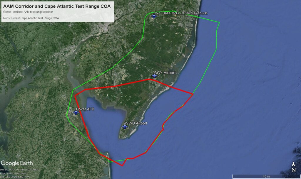
Positional Truth: Trajectrix Builds Multi‑Source Awareness for Autonomous Flight
By: Dawn Zoldi As beyond visual line of sight (BVLOS) operations and Advanced Air Mobility (AAM) move from trials to scaled services, the core question has changed from “Can we...Read More
In-Time Aviation Safety Management Systems: Preparing the NAS for Emerging Aviation
By: Juan Plaza, Autonomy Global Ambassador – Operations Safety For more than a century, the National Airspace System (NAS) has been shaped by the assumption that people fly, monitor and...Read More

AI, Digital Twins and the New Utility Playbook: Turning Data Deluge into Operational Decisions
By: Dawn Zoldi Utilities no longer simply keep the lights on and the taps flowing. They have rebuilt their entire operational DNA around data that actually moves, learns and predicts....Read More

UNIVITY: A 5G constellation for the connected vehicle
The automotive sector is experiencing an unprecedented expansion of connected services—from basic in-car telephony to advanced infotainment, HD navigation, massive Over-The-Air (OTA) updates, and soon V2X services. Yet behind this...Read More
ANELLO Photonics and Delta Black Aerospace Announce Partnership to Deliver Assured Navigation for Uncrewed Aircraft in GPS-Denied Environments
SANTA CLARA, Calif., Feb. 3, 2026 /PRNewswire/ — ANELLO Photonics, the creator of the Silicon Photonics Optical Gyroscope (SiPhOG™) and a leader in solid-state, high-precision inertial navigation systems, today announced a collaboration...Read More

Autonomy in Action: Top 10 Use Cases for Drones and Robotics in Energy and Utilities
By: Sylvia Ibarra, Energy Drone & Robotics Coalition (Autonomy Global Media Partner) As energy systems grow more complex and operational margins tighten, drones, robotics and AI continue to move from...Read More

Boeing and Ben-Gurion University Launch USD 10 Million Cybersecurity Center for Next-Generation Aviation Systems
By Arie Egozi, Autonomy Global – Ambassador for Israel Israel, a world leader in cybersecurity, and U.S.-based defense giant Boeing, has moved to leverage this expertise to secure its next...Read More

Sovereign, Secure and Resilient: Geospatial Infrastructure As National Security Infrastructure
By: Dawn Zoldi Geospatial infrastructure has moved from the back office to the front line of national security. At this year’s GeoBuiz Summit, the “Sovereign, Secure, and Resilient Geospatial Infrastructure...Read More

Has the Golden Dome Arrived? The New National Defense Strategy Could Rewrite America’s Drone and Counter‑Drone Future
By: Dawn Zoldi The newly released 2026 National Defense Strategy (NDS) resets how Washington thinks about drones over U.S. soil and the industrial base that builds and defeats them. It...Read More