By: Dawn Zoldi
As beyond visual line of sight (BVLOS) operations and Advanced Air Mobility (AAM) move from trials to scaled services, the core question has changed from “Can we fly?” to “Can we trust what we’re seeing in the sky?” Ray Adams, President of Trajectrix and a 31‑year air traffic control veteran, argues that the industry will only safely scale if it grounds every decision in validated positional truth, not single‑threaded GPS assumptions. His company, Trajectrix, positions itself as a foundational layer in that future by delivering a secure, multi‑source awareness service designed to make BVLOS operations repeatable, certifiable and resilient.
From New York ATC to New Airspace Architect
Adams’ perspective is shaped by decades in some of the most complex airspace on earth, from procedural oceanic sectors in the North Atlantic to radar control at New York Air Route Traffic Control Center and high-tempo terminal operations in Newark Airport’s Control Tower. There he learned to rely on layered surveillance and navigation, including radar, procedural separation and cooperative technologies working together, to keep dense traffic safely separated.
As talk of drones, large uncrewed aircraft and future air taxis looked to press into that same low‑altitude volume, he saw a dangerous oversimplification. Most emerging concepts leaned almost entirely on cooperative systems and GPS. “Everything is really based upon cooperative operations,” Adams explained. “It’s effectively ‘I’m going to use GPS to tell me where I am and I’m going to tell everybody else where I am.’” But GPS-based systems are not entirely reliable, at least not all the time. That gap, between how legacy air traffic control manages risk and how early BVLOS concepts were being framed, became the genesis of Trajectrix.
Why Cooperative-Only Solutions Aren’t Enough
Adams was blunt about the limits of GPS‑driven ADS‑B and similar cooperative tech as a primary surveillance layer. First, not everyone is visible by design. Military, law enforcement and some sensitive operations will not broadcast intent or position. Second, as ADS‑B has become ubiquitous, its dependence on GPS makes it a tempting and fragile target for spoofing and jamming. “Why are we allowing [ADS‑B] to be a primary method of surveillance and navigation in the national airspace system when we know it’s not resilient enough?” he queried.
Adams contrasts the “soft surveillance and soft comms” trend with the high‑power, hardened systems that have historically underpinned air traffic control. In his view, cooperative feeds are excellent for efficiency and situational awareness. They should be layered on top of independent surveillance, not just replace it.
This philosophy is especially relevant as the FAA finalizes its BVLOS rule, wrestles with electronic conspicuity and right‑of‑way constructs, and stands up automated data service providers under Part 146. For Adams, the winners in this next phase will be the teams that can prove not just that they “see” traffic, but that they can validate what they see. This same logic applies to military autonomous operations. (See Adams’ feature in Military Embedded Systems).
Inside Trajectrix: Secure Ground‑Based Detect and Alert

Trajectrix’s flagship solution, a secure ground‑based detect‑and‑alert service (S‑GBDAA) is essentially a federated, independent surveillance layer designed to plug into BVLOS and AAM operations, without exposing national‑security sensitive airspace data.
At a high level, Trajectrix uses existing FAA surveillance infrastructure and other independent sensors to generate an airspace picture that does not depend on the aircraft telling you where it is. It then wraps that picture in a secure architecture that minimizes cyber attack surfaces and prevents adversaries from reconstructing sensitive military or law‑enforcement movements. Finally, it delivers this feed as a supplemental detect‑and‑avoid and situational awareness input to remote pilots, autonomy stacks and AAM operators. “We’re providing the same information the air traffic control system uses to these remote pilots or autonomy stacks… as a source of positional truth,” Adams elaborated.
Crucially, on the commercial side, Adams and his team designed S‑GBDAA as a service layer that slots into safety cases and means‑of‑compliance packages. An operator seeking BVLOS approvals can point to it as a non‑cooperative surveillance input that extends detection range, improves conflict detection timelines and reduces reliance on last‑ditch collision‑avoidance maneuvers. Adams calls this “buying time.’ It could mean the difference between a violent TCAS‑style escape maneuver and a subtle heading or altitude change initiated early enough that no one on board, or on the ground, notices. “We don’t build our air traffic systems around single common failure points… Trajectrix is an attempt to build in some layers of redundancy based upon what I call positional truth,” Adams said.
Positional Truth: Multi‑Source Awareness as a Design Principle
“Positional truth” is Adams’ shorthand for what happens when multiple, independent sensor layers converge on the same picture. In practice, it means non‑cooperative radars and other sensors independently locate aircraft, then correlate that with cooperative feeds like ADS‑B, Remote ID and operator telemetry. In simple terms, according to Adams, “Positional truth means that we’re not relying upon the aircraft to tell us where it is.”
If the cooperative track starts to drift away from what independent sensors see, the system flags that divergence as a potential GPS issue, configuration error or active spoofing. The operator can be alerted that their navigation may be off, or that a non‑cooperative actor has entered the picture.
This mirrors long‑standing ATC practice, where controllers routinely compare reported barometric altitudes with radar‑derived altitude and instruct pilots to disable faulty reporting when discrepancies exceed thresholds. Trajectrix essentially brings that philosophy into the low‑altitude, highly automated environment that BVLOS and AAM will inhabit.
From Test Ranges to National Integration

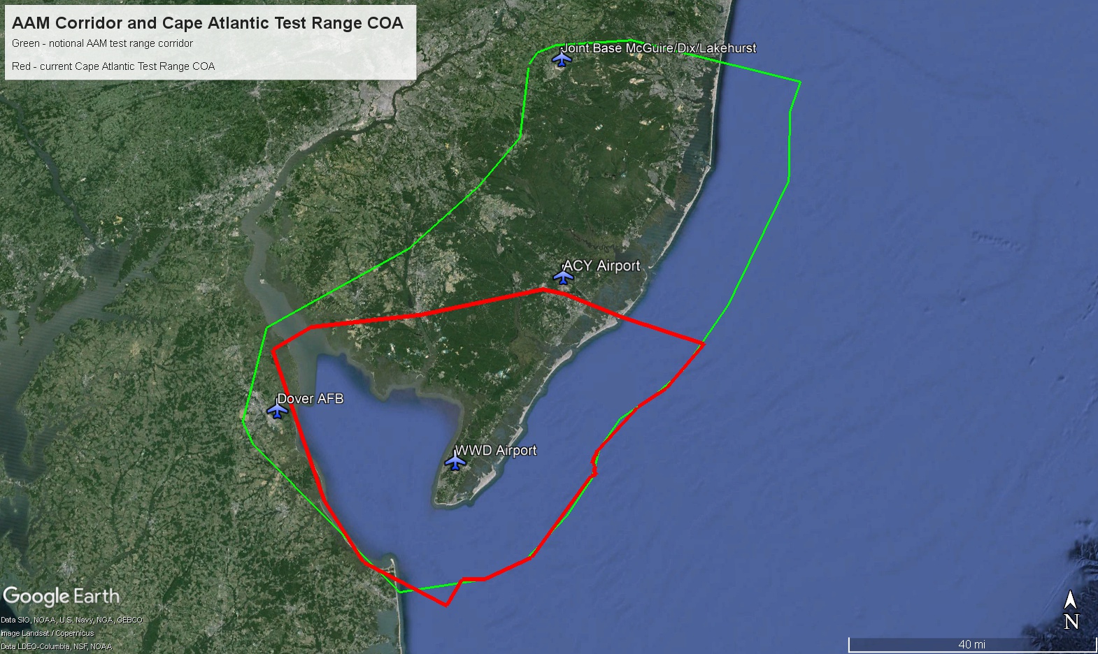
Trajectrix’s push for positional truth is not happening in isolation. The company is aligned with the Cape Atlantic UAS Test Range under the University of Alaska Fairbanks (ACUASI) umbrella, focusing on large UAS and integrated operations in some of the busiest airspace in the country.
The current range spans the southern tip of New Jersey up to around 7,000 feet, with an expansion in work that will stretch roughly 80 miles north‑south and 80 miles east‑west between Joint Base McGuire‑Dix‑Lakehurst and Dover Air Force Base. This corridor sits directly between Washington, DC and Boston, and between Philadelphia and New York, an environment where “sterile” segregated airspace is not realistic. “We don’t segregate. We integrate,” Adams noted. “All of our operations are integrated into airspace… we make things work with existing air traffic.”
Trajectrix is also a party to a cooperative research and development (CRADA) agreement with the U.S. Transportation Command and Air Mobility Command, focused on enabling logistics‑driven autonomy between major bases using these same independent surveillance concepts. The dual‑use nature of Trajectrix’s approach means that the same secure, federated S‑GBDAA architecture which underpins commercial cargo, middle‑mile logistics, and future air taxi routes can also protect sensitive military movements.
Inside the Federal Aviation Administration (FAA), Adams and his team have briefed senior leadership and are working with the Technical Center in New Jersey to begin validating Trajectrix’s service using real FAA surveillance data and, ultimately, live flights. As Part 146 automated data service provider (ADSP) frameworks mature and near‑term approval (NTAP) pathways evolve, S‑GBDAA remains a strong candidate to be recognized as a safety‑enhancing data service that can accelerate BVLOS approvals.
What Leaders Must Prioritize in 2026
Adams emphasized that the bottleneck to scale is not technology alone. It is proving, to regulators and the public, that your system behaves safely under real‑world stress. That means leaders need to:
- Move beyond GPS‑only assumptions and design architectures around independent, multi‑source awareness from day one.
- Treat detect‑and‑avoid as a layered system—strategic conflict management and early detection first, collision‑avoidance last.
- Invest in transparent risk modeling that regulators can interrogate: what happens when GPS fails, when spoofing occurs, when non‑cooperative traffic intersects your corridor?
“If you’re at the collision‑avoidance layer in the stack, you’re already too late,” Adams warned. In his view, the operators and OEMs that win the first wave of scalable BVLOS and AAM approvals will be the ones who can demonstrate validated data, resilient architectures, and credible answers to those “what if” scenarios. Trajectrix has built its multi‑source awareness platform to be one of the core tools in that safety case.
Where Positional Truth Becomes Real: Cape May and Beyond

One of the clearest windows into Trajectrix’s roadmap is the Cape Atlantic UAS Test Range and the ecosystem growing around it. In April 2026, Adams and his partners are bringing back the Cape May UAS Forum, now aptly renamed “Shore to Soar” as a deeply technical, three‑day event at the Cape May Convention Hall. It will culminate in an industry roundtable to shape the next phase of the range.
“We want to hear from industry what they need going forward and where the industry is going in the next 10 years so that we can develop the test range with the underlying infrastructure,” Adams explained.
As S‑GBDAA moves from R&D deployment toward certification and commercialization over the next two years, Cape May and the expanded corridor offer a real‑world sandbox where BVLOS cargo operators, AAM OEMs and defense users can prove out multi‑source awareness concepts at scale.
Where to Go Next to Dive Deeper
For operators, OEMs, and program leaders who see positional truth as a strategic advantage rather than a regulatory burden, Trajectrix offers both a technology stack and a set of hard‑earned lessons from legacy air traffic control.
To explore how S‑GBDAA and Trajectrix’s multi‑source awareness services could support your BVLOS or AAM program:
- Connect with Ray Adams on LinkedIn. He remains highly active in the AAM and UAS integration conversation.
- Engage with the Cape Atlantic UAS Test Range team (administered through Airde-Elevated and ACUASI) to scope trials in the New Jersey corridor.
- Watch Episode 106 of the Dawn of Autonomy podcast for the full discussion on where AAM is headed in 2026 and how validated data will define the leaders.
“All we can do is keep moving forward… but we have all the right people, we have the right connections, and I think we have the right technology,” Adams concluded.