By: Dawn Zoldi
Geographic Information Systems (GIS) have become indispensable to public safety, knitting together data, people and resources when disaster strikes. Nowhere was this more evident than during Hurricane Helene, when North Carolina’s geospatial community mobilized in unprecedented fashion to coordinate rapid response, direct search and rescue (SAR) and support rebuilding efforts across devastated mountain and coastal regions. As panelists at GeoGov25’s “Value of the Geospatial Ecosystem” plenary illustrated, the true value of GIS emerges not in isolated technology, but in the collaborative human ecosystem built on trust, fast access to accurate information and collectively solve problems before, during and after the storm.
Building the Geospatial Ecosystem: A Collaborative Human Endeavor Based on Trust
GIS does not exist in a vacuum. David Menasche of Google Public Sector, Amar Nayegandhi of Woolpert, Brad Kearse of NOAA, Hope Morgan of AECOM, Sallie Vaughn of Person County, NC and Gary Thompson of the NC Department of Public Safety presented a tapestry of experience that spans public, private and grassroots spheres. Their insights revealed that when agencies, communities and industry work in concert, GIS becomes a force multiplier by powering life-saving decisions, enabling smarter recovery and ensuring resilience long after the storm passes.

Hope Morgan’s words captured the ethos of contemporary emergency response: “If we can tell them ahead of time where these potential areas will be, it benefits [first responders] greatly and they now have the ability to respond better… That took a lot of time. There is no shortcut to trust.” Trust, speakers agreed, is the human glue that binds disparate databases, organizations and objectives together into a functioning geospatial safety net.
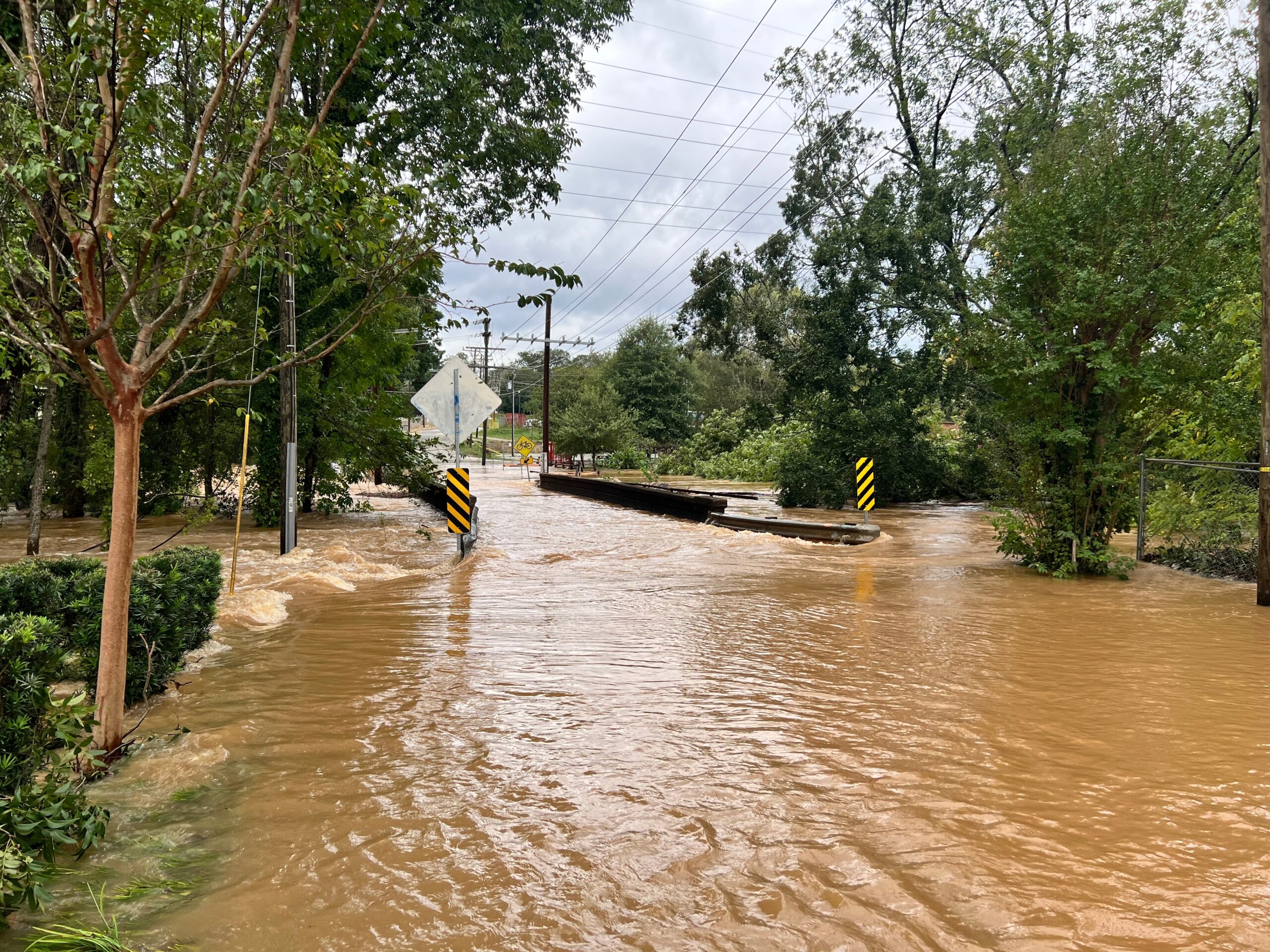
Hurricane Helene: Stress-Testing the GIS Infrastructure
Hurricane Helene battered North Carolina with record-breaking rainfall and devastation, presenting North Carolina’s hazard mitigation agencies with a daunting litany of disasters. “31 inches of rain in some areas… after 72 hours of saturation,” Morgan said, “seven confirmed tornadoes, one… 300 miles away from the impact area… 2217 landslides, [and] 2,848,000 people impacted.”
As the storm raged, an invisible network of technology became the backbone for emergency responders, local governments and recovery teams. GIS coordination guided data-driven decisions and community restoration.
Gary Thompson detailed North Carolina’s use of two crucial applications during Hurricane Helene: the Flood Mitigation Alert Network (FIMAN) and the Flood Risk Information System (FRIS). These platforms saw a surge in use as residents and agencies sought real-time updates on flood risks, enabled by a robust pipeline of remote sensing imagery and live gauge data (note: in flood monitoring, a “gauge” refers to an instrument or device—typically a stream gauge or river gauge—used to measure and record water levels (stage), flow, or discharge in rivers, streams, or flood-prone areas).
During Helene’s onslaught, Thompson’s team operated daily calls with federal and state partners to direct imagery collection, before, during, and after the hurricane. “One of our partners… does an outstanding job of collecting the imagery that was highly used… to help with change detection,” Thompson said. GIS undeniably had a frontline presence in identifying the evolving disaster landscape.
Data Integration, Rapid Assessment and Recovery
GIS enabled the assembly of essential digital assets for real-time flood monitoring and recovery. The workflow was not limited to one agency. Instead, a daily ritual of consensus calls guided which assets, like aerial photography, LIDAR and gauge data, were gathered. The result: near real-time flood warning systems that interfaced with transportation, public safety and local decisionmakers to direct search and rescue or resource deployment.
Brad Kearse of NOAA pointed to the dramatic evolution of technology since Hurricane Andrew in 1992. “It took weeks before we had the imagery available…[Now] it’s hours. Once they get on the ground, we work with all the partners… to get that information up to the users that need it in real time,” he recounted.
Ground-Level Coordination: Rural Challenges, Local Solutions
Sallie Vaughn shared the perspective from Madison County, a region hit hard during Helene. She described arriving at the county’s emergency operations center and prioritizing personal connection before technology: “I did not immediately go to work. I asked people, are you okay? Do you know where your family is? Was something destroyed? How can I help you?” By meeting local officials at their level, Vaughn cultivated crucial trust, always the launching point for effective GIS deployment.
Vaughn’s approach married practical field training with technology transfer. She taught building inspectors and environmental health personnel to use iPads for mobile mapping and digital damage assessments. In disaster conditions where “the only place [to get] internet was in a place my cell phone didn’t work,” the GIS team kept operations running from a USB drive loaded with local datasets. Vaughn’s lesson: “Sometimes [high] technology is not the answer; you’ve got to be prepared for the worst.”
LIDAR, Imagery and the Value of Consistent Data
Post-storm geospatial work also hinges on data accuracy and interoperability. As Thompson explained, “We have, in partnership with the UNC Chapel Hill North Carolina Lab, collected LIDAR data…to support a variety of applications: landslides, road and bridge reconstruction and ongoing floodplain mapping.” This ensemble of data sets provided state and federal agencies with a shared reference for decision-making, modeling and reconstruction.
NOAA’s National Geodetic Survey, led by Brad Kearse, continues to modernize the National Spatial Reference System, to ensure technical consistency across all emergency mapping. This cuts years off workflows that previously hampered recovery. Kearse illustrated the foundational value with a post-disaster anecdote: “How long it would have taken many years ago… to even produce a nautical chart. [Now] it was responded to… within weeks. That’s because of this whole geospatial community we live in.”
Managing the Data Deluge and the Need for Analysis
With disasters come floods, not just of water, but of data. The true value of GIS lies not merely in acquisition but in its capacity for synthesis, analysis, and actionable insight.

Morgan observed, “When a storm comes through, the entire world shows up and hands you data. You have no idea what to do with it.” Frantic data handoffs, imagery from dozens of sources, meant teams sometimes had to muster volunteers just to comb through the visual evidence for actionable intelligence.
Panelists stressed the importance of requesting not just raw data but analytical deliverables: synthesized assessments, interpreted results and decision-ready products. Morgan noted, “AI is a big part of this, but also for the assessment… so that you could just do the analysis instead of figuring out what data you have before you do the analysis.”
Gaps, Foundations and Data Equity
Beneath the visible gains, vulnerability persists. Rural communities often lack even basic geospatial layers such as fire hydrant maps, other critical infrastructure datasets or the resources to keep them current.
“Everything that we’ve talked about… is assuming that the data exists. …I can tell you that we don’t have the data,” Vaughn lamented. The insurance industry, she noted, typically maintains excellent records. The challenge is connecting the dots between public need and private data stewardship.
To bridge these gaps, panelists imagined deeper collaboration between volunteers, industry partnerships and new “strike teams” equipped to fill in the foundational layers most at risk of obsolescence. GIS professionals must focus not just on sophisticated analytics, but on extending the public good to those left out of the digital infrastructure build-out.
Interoperability, Reference Frames and the Path Forward
Commitment to a common geospatial reference system remains paramount. Consistent national frameworks, easy data access and streamlined workflows have already shortened recovery timelines and made emergency response smarter. Yet, as panelists emphasized, the sector must remain vigilant.
“There are a lot of people that are using this data that don’t know they’re using it, don’t know how to use it, and just don’t realize that they’re using it wrong,” Vaughn said. She argued for more training, documentation and outreach as GIS weaves itself deeper into the fabric of public life.

Amar Nayegandhi called for easier access to high-quality geospatial products when they matter most. “Collaboration is happening. It’s how easily we can access the data when we really, really need it.” The challenge for the geospatial community is not only to innovate, but to make those advancements universally accessible, particularly at the times of greatest crisis.
GIS as the Quiet Backbone of Public Good
In the wake of Helene, the value proposition of GIS moved from theoretical to undeniable reality. This story, told by this coalition that spanned local counties to international firms, highlights the steady hands, practiced workflows and persistent data-sharing that define GIS for public good. In moments of chaos, consistent coordinates, current imagery, resilient infrastructure and, above all, human relationships prove indispensable.
As Thompson summarized: “Collect data. One for local uses. And tell them that you’re going to collect it so that they can add on to it if they need something else… We’ve come a long way with the coordination and geospatial data.”
The future of hurricane response, and by extension, the safeguarding of communities across the world, will increasingly depend on robust GIS, built on trust, partnership, and an unrelenting commitment to the public good.