By: Dawn Zoldi and Dahlia Kopycienski
Using NASA lidar, lean processing workflows and browser‑based 3D visualization, Terra Incognita Research Institute and Stitch3D have outlined a practical way to find, and convincingly show, evidence of large ancient settlements hidden under the Amazon canopy. Their work, highlighted at Geo Week 2026’s “Finding Lost Civilizations – How Lidar Uncovered Ancient Cities in the Amazon” session, provides key lessons for stakeholders about mature remote sensing, real constraints and geospatial tools that people can actually use in the field…and in the browser.
From “Empty” Forest to Structured Terrain

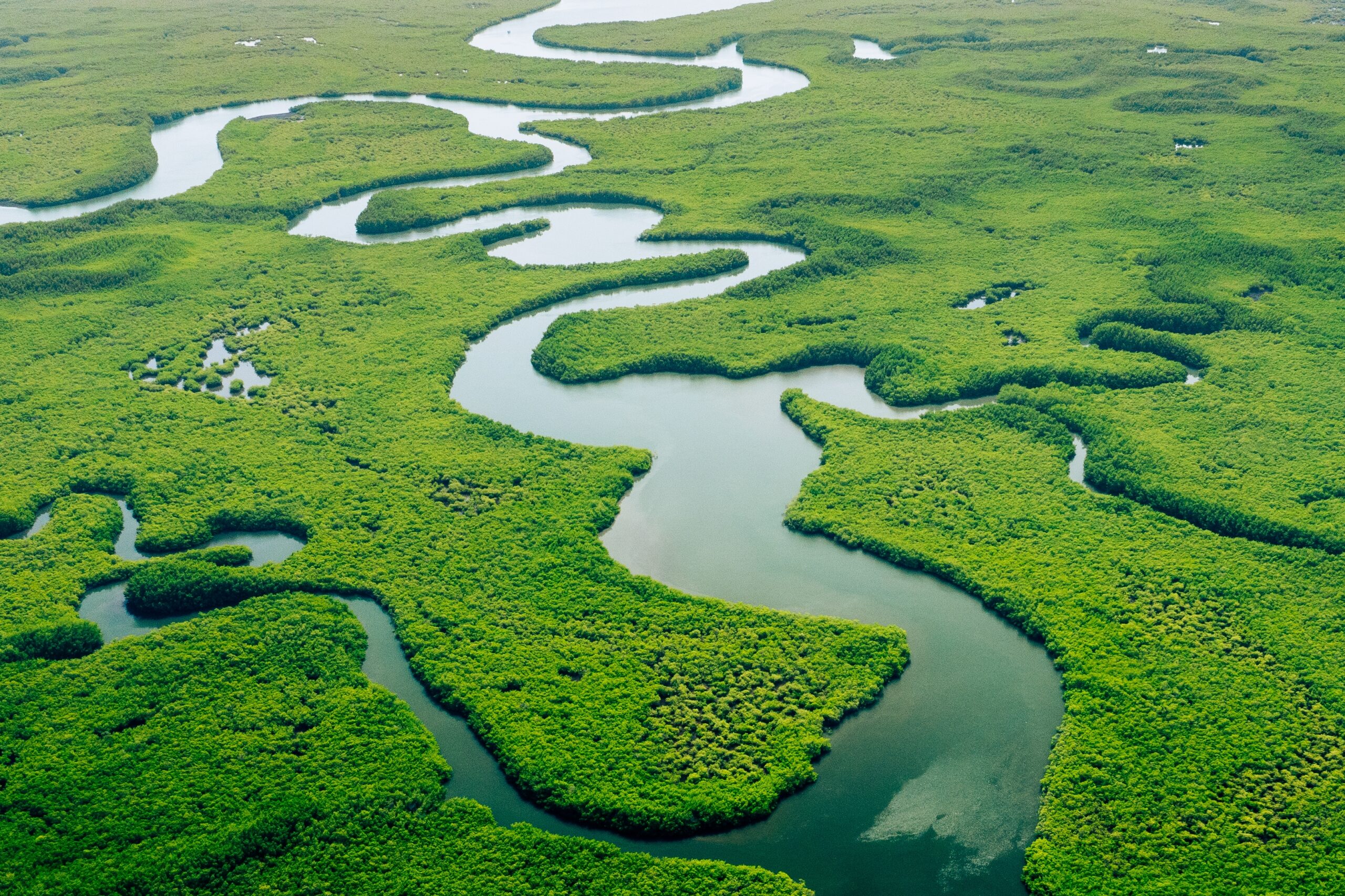
For most of the last century, the central Amazon barely registered in debates over complex pre‑Columbian societies. The prevailing view held that soils were too poor, canopy too dense and logistics too difficult to support large, long‑lived settlements. When geometric earthworks, or geoglyphs, began emerging in deforested ranchland in southwestern Brazil a decade or so ago, that picture started to change. Even so, the narrative still centered on areas where modern clearing had done the visibility work.
Terra Incognita pushed the question into the intact rainforest. Co‑founders Dr. Daniel Pierce and Christopher Bodine targeted a sparsely mapped region of the Rio Negro basin near Barcelos, far from known urban centers. Their hypothesis was that if lidar could reveal organized earthworks in this supposedly marginal zone, the Amazon’s settlement history would need a serious upgrade.
The lidar they used was never designed for archaeology. NASA collected it for canopy‑health and post‑fire recovery studies. This left the team with low‑density point clouds and only about 4,000 acres of coverage in a region Pierce estimated at tens of millions of acres. That forced them into a forensic approach to treat every tile as a potential bare‑earth signal, not a ready‑made site map.
“We took NASA lidar that was never collected for archaeology, ran it through a pretty bare‑bones processing pipeline, and still pulled out a kilometer‑long earthwork that no one on the ground knew was there.”
Dr. Daniel Pierce, co‑founder and lead researcher at Terra Incognita
Kitchen‑Table Remote Sensing
Working from home on university hardware, Pierce ran “hundreds” of NASA tiles through a repeatable but pragmatic workflow. He aimed to peel back vegetation, expose ground and make subtle, non‑natural geometry pop. That meant:
- Generating bare‑earth terrain models from the lidar to remove canopy and see the land surface.
- Applying edge‑detection and local‑relief shading to sharpen ditches, embankments and other linear features that don’t match natural drainage.
- Flipping between 2D shaded relief and 3D point‑cloud perspectives to confirm that promising shapes held together over distance rather than collapsing into noise.
Most tiles showed only forest and rock islands. Then one tile surfaced with a different pattern: a straight, almost kilometer‑long linear feature trending toward the river, paired with a large geometric earthwork barely visible under the digital canopy. In a jungle river system where natural channels meander, that straightness and scale were strong indicators of human construction.
Ground Truth in a Hard Place
Finding a feature in a point cloud is one thing, but betting an entire field season and crowdfunded support on it is quite another. Terra Incognita organized an expedition around that single anomaly.

The target sat roughly 150 miles upriver from the nearest road, inside a Brazilian reserve. The team first navigated national heritage and environmental permits, then approvals from individual Indigenous communities along the river system. Even with documents in hand, village presidents retained veto power when the team arrived at their docks.
River timing became a mission constraint. In peak wet season, floods and storms can halt movement and submerge survey locations. In peak dry season, water levels drop too low for boats. The team chose December, at the start of the wet season, hoping upstream rainfall had lifted water just enough to pass without drowning the beaches and banks they needed to reach.
On the Rio Negro and its tributary, they travelled by day and stopped an hour before dark to cut campsites, rig shelters and string hammocks. The river’s tannin‑rich water kept mosquito levels surprisingly low, but other risks remained, including vampire bats capable of transmitting rabies through unnoticed night bites, venomous snakes, caiman and the fact that the nearest medical facility was about 30 hours away. Illegal logging and other informal economies added a human‑security layer to the risk profile.
Near the coordinates derived from the NASA tile, the team reached a village founded only about 40 years ago. Locals knew about pottery eroding from the riverbank and carvings on nearby rock outcrops, but they had no idea they were living beside a massive, buried geoglyph and an ancient road, both invisible from ground level under intact forest.
Using GNSS and printed terrain models aligned to the processed lidar, Pierce and Bodine walked into the jungle until their position matched the feature they’d modeled. The canopy still looked uniform, but as they paced distances and measured subtle changes in elevation, the ground profile mirrored the digital model, as a straight, broad ditch and embankment running nearly a kilometer toward the river. Across the surrounding surface, they recorded thousands of ceramic sherds in a compact footprint, more akin to long‑term urban occupation than a temporary camp.
“We rely on lidar to tell us where to look, but it’s the moment your boots hit the ground and the terrain matches the model that you know you’re standing in a lost landscape.”
Christopher Bodine, co‑founder and lead researcher at Terra Incognita
Taken together, the earthworks and material density pointed to a large, long‑occupied settlement that likely depended on intensive agriculture and complex division of labor to support months‑long construction projects.
Phone‑to‑3D: Petroglyphs on the Fly
Some of the most striking 3D evidence came from a device most people carry. After the geoglyph work, local men invited the team to see “something cool” and led them by boat to a rock island in mid‑river. Low water had exposed slabs covered in petroglyphs: monkeys, birds, crocodiles and human‑like figures carved into the stone.
This leg of the trip wasn’t equipped with dedicated scanners, so Pierce pulled out his phone. By walking careful overlapping paths and later processing the imagery, he generated photogrammetric models of the panel. In standard photographs, the carvings were hard to see under lichen and uneven lighting. In elevation‑based visualizations, the figures snapped into focus. Individual motifs, some around six feet long, could be measured and compared.
The resultant layered 3D workflow involved airborne lidar for regional context and feature detection, and phone‑based photogrammetry for high‑resolution capture once teams are on site.
Stitch3D: From Hard Drives to Hyperlinks
Even with solid remote sensing and field verification, Terra Incognita still faced the familiar geospatial problem of large, complex data that almost no one outside the project could open. Raw point clouds and derivatives don’t travel well by email. University storage systems balk at multi‑gigabyte files. Newsrooms and donors often lack specialist software and ask, reasonably, to “see the data,” not just screenshots.

Stitch3D joined the project to break that bottleneck. Founder and CEO Clark Yuan originally built the company’s cloud‑native platform with support from the U.S. Air Force, with the goal of enabling non‑engineers inspect and measure 3D spatial data, like runway craters, directly in a browser. The same design translated neatly to archaeology.
For Terra Nova, Stitch3D ingested both public Amazon geoglyph datasets and the NASA‑derived scene of the newly identified site. At Geo Week 2026, Yuan shared a QR code with the audience where up to 50 participants could immediately join a live browser session showing the actual point cloud and terrain model. On phones or laptops they could:
- Toggle between 3D point‑cloud and 2D terrain views, with canopy stripped away.
- Rotate, zoom and pan using simple touch or mouse gestures.
- Adjust vertical exaggeration and take real‑time measurements of ditch depth, embankment height and feature length.
That experience turned a narrative panel into an interactive, geospatial briefing. Stakeholders saw for themselves how a straight, nearly kilometer‑long earthwork emerged only after removing the canopy. Reporters and potential donors gained enough intuition about the site to ask better questions, and to grasp why this wasn’t just an “anomaly” on a screen.
For Pierce, the platform also fixed their day‑to‑day workflow. Instead of wrestling with institutional file‑sharing limits and teaching reporters how to open point clouds, he can now just send links. He has begun uploading other projects because the browser‑first interface makes it easy to interrogate 3D scenes without friction.
Takeaways for Autonomy, Geospatial Crowd & Decision Makers
At the intersection of autonomy, geospatial tech and decision‑making, Terra Incognita’s Amazon work offers lessons learned:
- The sensing layer can be opportunistic. NASA lidar collected for canopy health became an archaeological reconnaissance asset once processed into bare‑earth models and enhanced for micro‑relief.
- The compute layer can be pragmatic. Kitchen‑table workflows on university hardware still delivered high‑value signals when paired with domain expertise and disciplined interpretation.
The field layer can stay light. GNSS receivers, phones and basic river logistics were enough to ground‑truth a major site in one of the world’s hardest environments.