By: Dr. Rebekah Yang, CNA
On a recent day in Howard County, Maryland, the skies bustled with activity as drones delivered packages and meals. Over 15,000 small uncrewed aircraft system (UAS) flights were launched from two warehouses and three fast-food outlets throughout the day. However, issues arose in areas where drone traffic became too congested. French fries cooled, packages were delayed and deliveries arrived an average of 52 minutes late. Nearly eight percent of deliveries were so delayed that they were ultimately canceled. In reality, no residents of Howard County went hungry that day. The entire operation was simulated using CNA’s UAS Cooperative Airspace Traffic Simulation tool, UCATS™.
CNA developed the UCATS™ tool to assist government and industry stakeholders to model various flight planning scenarios. With a growing number of use cases and users, UAS are posed to enter the national airspace system (NAS) at a high rate. This will bring numerous challenges related to safety, logistics and policy, which are all made even more complex with high-density operations. To understand the impact of rules and corresponding operator behavior on a given UAS ecosystem, innovative tools are needed—and that is precisely what prompted CNA to invest its own funds into developing UCATS.™
Getting to Know CNA
CNA is an independent not-for-profit research and analysis organization whose staff routinely explore solutions to future challenges facing the U.S. government. At CNA, our staff are eager to apply technical rigor to new challenges.
We have demonstrated the ability to research and create other simulation tools, such as the SAFER-C™ tool that was used by correctional facility leaders to make informed re-opening decisions during the COVID-19 pandemic.
In the aviation community, we have supported the FAA for more than 30 years in modernizing air traffic management and, more recently, in preparing for new entrants into the NAS, such as UAS and Advanced Air Mobility (AAM).
The Need for Insights
Unlike traditional air traffic, UAS traffic management (UTM) will be cooperative and community-based. This means that competing users will have to work together to create an operational ecosystem that can support a range of various business needs—from package deliveries to life-saving medical and emergency response operations. Although the Federal Aviation Administration (FAA) will define the “rules of the road,” the operators and third-party UAS service providers will be responsible for coordinating, executing and managing operations.
Without a centralized regulator such as the FAA controlling individual aircraft, the UAS ecosystem must be safe, functional and accessible to competing operators. While observing the maturation of UTM from concept to operational evaluations at the Fort Worth Key Site for the near-term realization of low-density UAS operations, we saw the imminent need to provide insights into flight planning, especially for high-density operations.
Why UCATS™?
Tools like UCATS™ enable the safe and efficient integration of new entrants into the NAS by ensuring that concepts become reality through regulations that have been robustly developed and evaluated.
UCATS™ identifies key factors that influence the operational outcomes of the UAS ecosystem. This adaptable, data-driven tool enables the exploration of critical questions that operators and regulators must address to effectively manage the future of high density UAS operations.
This data will assist policy-makers and affected communities in understanding the causes and effects of proposed rules and protocols, especially as operational density increases.
How It Works
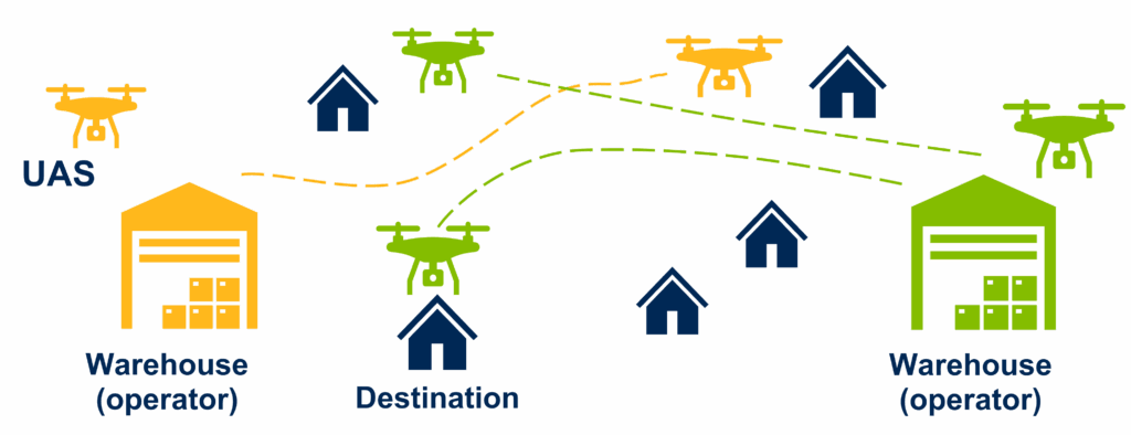
CNA’s UCATS™ tool simulates the flight planning process for UAS operations using agent based modeling (ABM), a computational methodology that uses a bottom-up approach to analyze the individual impacts of “self-acting” agents (UAS operators) on the overall system (UAS ecosystem).

UCATS™ is flexible and adaptable to various regions, types of UAS operations, operator preferences, flight volumes, timeframes, and more. Scenarios with a set of assumptions can be run thousands of times with randomized parameters (e.g., flight paths) to capture a range of possible outcomes.
To evaluate a scenario, UCATS™ generates (or is given) flight plans, such as those from package delivery operators, that specify the intent of each desired UAS operation, including departure time and trajectory.
The model uses ABM to simulate the scheduling of all flight plans within the given timeframe, deconflicting flight plans based on a first-filed-first served protocol if their trajectories overlap in space and time. UCATS™ then outputs whether each flight plan was:
- Scheduled as planned
- Delayed to avoid conflicts with other flight plans or
- Cancelled because of unresolvable conflicts.
The model can also output key metrics such as average delay per plan, number of resolvable conflicts and airspace sectors with the most conflicts. These outcomes can be grouped by characteristics (e.g., operator or time of day) to generate insights into ecosystem behavior. Various operational scenarios can be evaluated in UCATS,™ including factors such as:
- Traffic levels: varying flight volume over the simulation timeframe
- Airspace density: varying separation needs for aircraft
- Restricted areas: closing off defined areas of airspace at specific times
- Operator types: varying operator preferences such as operational area, operating hours and delay tolerance
- Operator behavior: adjusting departure time because of known restrictions
Additional scenarios can be added to UCATS™ with relative ease because of the bottom-up approach used in the tool’s design. Using a systematic approach, UCATS™ provides data driven insights on what-if scenarios that can be tailored to a vast set of possible constraints and assumptions.
UCATS™ In Action
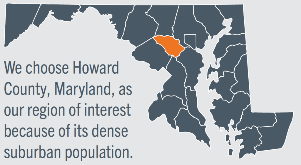
The CNA team used UCATS™ to simulate drone deliveries in Howard County, Maryland, a densely populated suburban area with over 102,000 eligible delivery addresses. To model future drone operations in 2035, the simulation included two fictitious package delivery warehouses—Elkridge Warehouse in the southwest and Ellicott City Warehouse in the northeast—positioned near major transportation hubs. Each warehouse served a 10-mile delivery radius, resulting in significant overlap between their service areas. Over a 12-hour period, the warehouses operated a total of 12,000 package deliveries, scheduled with varying file-ahead times (next day, same day, or one hour).

To explore the impact of time-sensitive deliveries, the simulation added three fast-food distribution hubs operating within a 3-mile radius during lunchtime hours (11 AM to 2 PM). These hubs handled between 700 to 1,500 orders daily and canceled flights delayed by more than an hour. The fast-food locations were strategically placed to overlap with each other and the package delivery zones to reflect real-world food establishment hubs.
The simulation divided Howard County into 300-by-300-foot sectors to create a regional grid. Drone trajectories were pre-generated using a shortest-path algorithm to travel from an origin sector to a destination sector, and back. The drones traveled at 50 miles per hour, crossing each sector in five seconds.
Results from 1,000 iterations revealed significant challenges:
- Nearly 70% of flight plans experienced delays averaging 60 minutes.
- Approximately 9% of flight plans were canceled.
- Congestion was most severe near warehouse takeoff and landing zones and along flight corridors generated by the shortest-path algorithm.
- Flights planned farther in advance had a distinct advantage; none of the flights scheduled 12 or 24 hours ahead were canceled.
- Operators handling time-sensitive deliveries faced greater difficulties securing optimal flight plans due to increased competition for airspace.
This simulation illustrated UCATS™’s ability to identify bottlenecks and optimize airspace management strategies for future drone operations.
Stakeholders That Benefit
UCATS™ offers transformative capabilities for both industry and government stakeholders, enabling them to address critical challenges in managing future UAS operations.
Industry stakeholders can leverage UCATS™ to:
- Strategically plan warehouse and delivery locations, operational capacities, and UAS fleet requirements.
- Analyze the impact of lead times on delivery requests to optimize scheduling.
- Develop pricing strategies based on file-ahead times and desired delivery windows, ensuring efficiency and profitability.
Government stakeholders benefit from UCATS™ by:
- Assessing deconfliction schemes and ensuring fairness among third-party UAS operators and service providers.
- Evaluating the use of air corridors to streamline drone traffic management.
- Preparing for peak capacity periods, such as holidays or specific times of day, to maintain smooth operations.
By addressing the unique needs of these stakeholders, UCATS™ serves as a vital tool for navigating the complexities of future drone integration into everyday logistics and airspace management.
What’s Next
Although UCATS™ has been used to evaluate delivery operations in our past studies, its framework can be adapted to additional types of operations and system protocols.
For example, deconfliction protocols beyond first-filed-first-served can be explored for their effect on perceived fairness by operators. The impact of considering prioritization of operations, one of the hottest UTM topics, can also be implemented into UCATS™ to simulate public safety or medical delivery flights.
As the widespread integration of UAS into the NAS approaches, the UAS community and regulators need innovative tools and methods that can help manage future airspace safely. Solutions such as UCATS™ offer the UAS community valuable data-driven tools to evaluate the effect of future decisions on the UAS ecosystem.
Visit the CNA UCATS™ page to download our case study, listen to CNA analysts discuss the tool in a podcast or scroll through an interactive story page on the tool.

