By: Dawn Zoldi
MatrixSpace has just done something many airspace awareness vendors promise, but rarely deliver. It turned radar from a point sensor into the centerpiece of a multi-sensor, AI-native system that scales from a single box on a tripod to a cloud-connected enterprise mesh. As the number of drone incursions, beyond visual line of sight (BVLOS) operations increase and complex urban events increase, that evolution matters. It gives operators a practical way to see, understand and act on everything moving in their low-altitude airspace, without forcing them to rip and replace the systems on which they already rely.
Smart Radar To Full-Stack Airspace Awareness
Until now, MatrixSpace was best known for its ultra-portable 360 Radar, the MatrixSpace Portable 360. A low-power, easily deployed sensor, it won over defense and public safety users who needed real airspace awareness without a truckload of gear. Those systems already shipped with edge AI that could classify targets as drone, bird or aircraft by interpreting subtle radar signatures, which dramatically improved the usefulness of raw tracks.
A critical differentiator of MatrixSpace gear is ultra low power operation. Their radars consume less than half the power of other solutions, which enables high levels of portability and long operation from small batteries or other power sources.
Recently announced upgrades move MatrixSpace from a “smart radar” company to a full-stack platform provider. On the software side, the company just introduced a multi-sensor MatrixSpace AI Platform that combines AiEdge at the sensor and AiCloud in the cloud. It fuses radar, optical, ADS‑B and Remote Identification (Remote ID) into a single, high-confidence picture of the low airspace. On the hardware side, its new Fusion 360 packages radar, Remote ID and a pan‑tilt‑zoom (PTZ) camera into an integrated airspace awareness system designed for either portable or fixed-site deployments.
AiEdge: Multi-Sensor Fusion At The Edge

The most important software change from MatrixSpace sits at the edge. Earlier versions of MatrixSpace’s radar could add on an optional perception module that ran AI close to the sensor to classify radar tracks and attach richer metadata (think: size, likely platform class, and behavior), on top of standard telemetry. That capability has now evolved into MatrixSpace AiEdge, an embedded operating environment that not only performs object recognition and classification, but also fuses multiple sensor feeds in real time directly at the node.
AiEdge runs on a compact, rugged GPU co-located with the radar, to execute bandwidth- and compute-intensive processing on-device rather than backhauling raw data to the cloud. It merges radar, optical and Remote ID inputs into a single, correlated track per object, using dynamic clutter filtering and rapid environment learning to suppress nuisance returns and emphasize likely threats. This layered, multi-sensor intelligence improves confidence and reaction speed in congested, low-altitude environments around airports, stadiums, borders, ports and sensitive facilities.
Many airspace awareness stacks still treat radar, optics and Remote ID as loosely coupled feeds stitched together in a C2 layer. MatrixSpace is pushing more of that correlation down into AiEdge, which especially matters when links to the cloud are intermittent or contested.
Crucially for existing customers, the new multi-sensor fusion capability is not limited to fresh hardware. From the outset, MatrixSpace designed systems on its original 360 Radar to support seamless firmware and software updates. This means early deployments can be upgraded to the latest AiEdge features through over‑the‑air updates, rather than wholesale replacements. Going forward, the AiEdge license will come standard with every MatrixSpace system for an AI-native baseline.
AiCloud: Single Pane Of Glass, Open By Design
AiEdge is where the sensing and fusion happen. MatrixSpace AiCloud is where operators see and act on it.
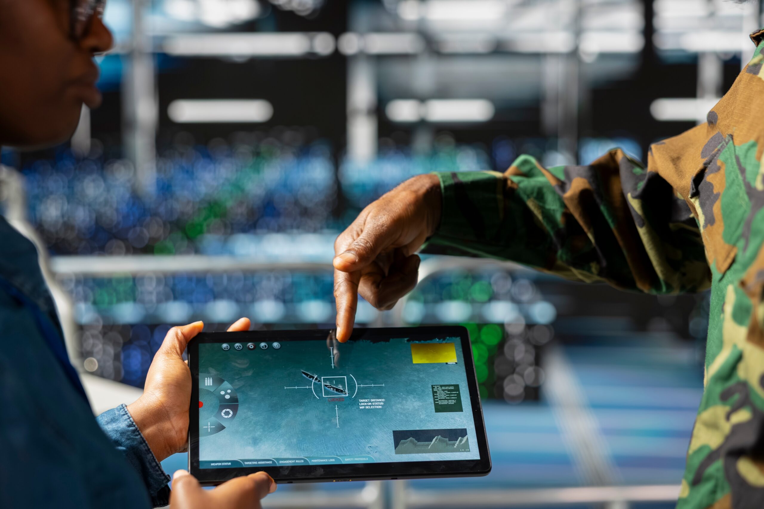
AiCloud aggregates data from AiEdge-enabled sensors, including radar, optical, ADS‑B and Remote ID, into a single, intelligent pane of glass accessible through a browser-based portal. Operators can visualize distributed clusters of nodes and sites, share a common operating picture (COP) with partners, and manage wide-area deployments from a central command post or on a tablet in the field. AiCloud will be extended to any future sensor type, and rapidly adapts to new sensor or mitigation options.
In this way, the upgraded system builds threat detection around selective confidence rather than raw alerts. Users can define whitelists of known friendly drones, set customized alert zones and apply confidence thresholds so that notifications only trigger when the fused sensor picture reaches a defined level of certainty. Within AiCloud, targets can be labeled friendly, unknown or hostile, and “keep-out” polygons give operators precise digital perimeters to monitor and defend.
From an integration standpoint, MatrixSpace deliberately built AiCloud to be open rather than closed. The platform offers web-based APIs, supports familiar protocols like REST, MQTT and WebSockets, and includes native connectors for TAK/(A)TAK, NINJA and SAPIENT. This enables tight integration into existing command-and-control (C2), public safety and defense systems. MatrixSpace is already engaged with organizations exploring direct AI Cloud integration into their C2 stacks.
AiCloud can run in public or private clouds, offers zero-trust security features, automated sensor provisioning and extensive historical storage for up to a year in the cloud, and at least 30 days on each device for pattern-of-life analysis and after-action review. If connectivity drops, AiEdge nodes continue operating autonomously and synchronize stored data once links are restored. This capability is crucial for contested or bandwidth-limited environments.
Fusion 360: An Integrated Airspace Awareness Stack

To fully exploit its AI platform, MatrixSpace has now also introduced Fusion 360, a compact, multi-sensor hardware system that brings radar, Remote ID and optical sensing together in one deployable package. Built on the company’s existing 360 Radar architecture, Fusion 360 adds an omnidirectional Remote ID scanner and integrated PTZ camera to form a 360-degree detection and visual confirmation stack for C‑UAS and airspace security missions.
The company designed Fusion 360 for both rapid-response and fixed-site operations. Leveraging its award-winning portable radar technology, the system offers panoramic coverage with low power draw, small footprint and quick setup, while also fitting permanent installations at critical infrastructure sites. AiEdge on the node fuses radar, camera and Remote ID inputs into a single, verified track per target, and applies progressive confidence scoring so operators only respond when there’s a real problem to solve.
The system automatically cues the PTZ camera to radar tracks and provides eyes-on confirmation. This capability extends into night operations through infrared optics. It also uses long-range, multiband Remote ID scanning to identify drone ID, type, telemetry, launch point and pilot location. This combination gives security teams the intelligence to respond at the source, rather than just chasing objects in the sky.
MatrixSpace is positioning Fusion 360 as a cost-conscious drone detection option in a space dominated by high‑end, fixed installations, especially for agencies that need to start small and scale. Its secure‑by‑design architecture supports authenticated, encrypted remote access and resilient operations even if network connectivity is degraded. Out of the box, it plugs into the AiEdge/AiCloud stack to allow organizations to start small and scale to additional nodes, sites, sensors or analytics as requirements grow.
Use Case Spotlight: Public Safety TAK-Enabled Awareness For Complex Events

While MatrixSpace has clear traction with defense and critical infrastructure customers, the new platform is also tailored to public safety agencies that increasingly find themselves responsible for low‑altitude airspace at major events and in urban environments.
Imagine a metropolitan police department that has to secure a downtown stadium and adjacent fan zones during a high-profile international match. In a plausible deployment, officers could position several Fusion 360 units on rooftops and mobile masts around the venue, each pairing a 360 Radar, Remote ID scanner and PTZ camera.
At the edge, AiEdge fuses sensor feeds to detect and classify drones approaching the stadium envelope, filtering out birds and clutter while correlating Remote ID broadcasts with radar tracks. As confidence builds that a track represents a non-compliant drone, AiEdge cues the camera to the target and pushes a high-confidence, fused track to AiCloud.
In the command post, AiCloud presents a unified view of the low airspace, with keep‑out polygons drawn around the stadium and pedestrian corridors. The system automatically whitelists drones operated by vetted media and approved service providers, which reduces alert fatigue while highlighting unknown or hostile tracks for rapid assessment.
Because the platform exposes TAK-native interfaces, field teams equipped with ATAK/TAK devices can see relevant airspace tracks on their own maps, even when they do not have full AiCloud access. This edge-to-cloud-to-handheld continuum gives incident commanders and on-the-ground units a shared, real-time understanding of the air picture, while still allowing agencies to retain their preferred C2 tools and workflows.
For grant-funded public safety programs chasing dollars tied to major events, critical infrastructure and urban resilience, the combination of portable, low‑power radar; Remote ID; visual confirmation; and a cloud-based, API-driven platform positions MatrixSpace as a viable, scalable backbone for airspace awareness.
From Device Vendor To Ecosystem Player
A significant strategic shift underlies all of these product announcements. MatrixSpace has just moved from being simply a radar device company with strong AI features, to a systems company with a broader platform of AI software and hardware. Its goal is not just to offer another standalone airspace awareness solution, but rather to create an ecosystem that can plug into others: UTM providers, public safety C2 suites, defense mission systems and specialized analytics platforms.
That ecosystem focus counts in a market where agencies and enterprises remain wary of proprietary silos. With AiEdge and AiCloud architected around open APIs and existing tactical standards, MatrixSpace has positioned its platform as a connective tissue layer that can feed and be fed by other systems, from TAK servers to emerging UTM/C‑UAS hybrids. As BVLOS operations expand and drone traffic management converges with airspace security, radar-centric, multi-sensor platforms like MatrixSpace’s will likely be judged as much on how they integrate as on how they detect.
For now, the company has delivered on two fronts that matter to operators: a meaningful upgrade to its AI Edge to Cloud software stack, and a practical, deployable Fusion 360 system that turns those software advances into tangible situational awareness in the field.